Brunton Compass Tutorial
Brunton Compass Tutorial
Introduction
Azimuths vs. Quadrants
Magnetic Declination (basic concept this page)
Magnetic Declination (detailed information
on separate page)
The Brunton Compass
Recommended Readings
see
also the Silva compass - separate page
Compass Tutorial
By permission with thanks to
Copyright © 1998 Steven H. Schimmrich
Introduction
Imagine yourself far out to sea, no land in sight, sailing in a small ship. During the day, you navigate by the sun and at night by the stars. Then it becomes overcast for several long days. I'll bet you wish you had a compass...
The interesting magnetic properties of lodestone, a mineral known as magnetite (Fe 3 O 4 ) to geologists, have been known since the time of the ancient Greeks. It wasn't until centuries later when mariners in China (and, by the 12th century, mariners in Europe) noticed that a piece of lodestone, when floated on a stick in a bowl of water, aligned itself to point in the direction of the north star. This was a discovery which revolutionized the world since it allowed for improved seafaring navigation and exploration. This simple discovery has been developed, over time, into the modern compass.
Compasses work because the earth acts like a giant bar magnet. Motions in the liquid nickel-iron core of the earth induce a magnetic field with a north and south pole. Magnetic lines of force connect the earth's north and south magnetic poles as show below:
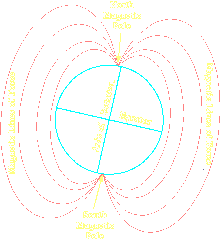
Compasses work because a magnetized compass needle will align itself with the earth's magnetic lines of force and point approximately north. I said approximately because you'll note in the figure above that the north and south magnetic poles don't exactly align with the earth's axis of rotation which defines the north and south geographic poles. We'll discuss this important fact shortly.
Structural geologists use compasses to create geologic maps and measure the orientations of geologic structures. Therefore, in order to do structural geology research in the field, you need to know how a compass works and how to properly use one.
Azimuths vs. Quadrants
There are three common ways to express a direction with a compass. The first is to simply estimate your direction as north, east, south, or west. If you want a little more precision, you can use northeast, northwest, southeast, or southwest as well. For this purpose, the compass below would work fine.
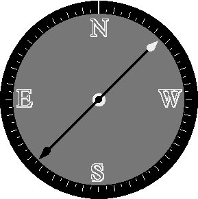
Let's take a moment to make sure we understand how such a compass works. Do you know why, for example, that E (east) and W (west) appear reversed on the compass above?
The compass needle is magnetic and aligns itself with the earth's magnetic field such that the white end of the needle points toward the north magnetic pole (we'll talk about the difference between the geographic north pole and the magnetic north pole shortly). Let's hold a compass while we're facing north. The arrow and the N on the compass will line up as shown below on the left.
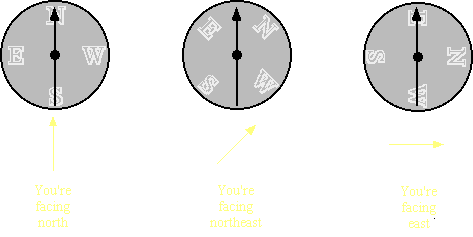
Now let's turn and face northeast. The compass needle doesn't move, it always points north, and now it's located half-way between the N and the E (northeast) on the compass. Let's keep turning and face east. The compass needle is still pointing toward the north but now it lines up with the E on the compass indicating that we're facing east. See why the E and W on compass faces are reversed?
While such a compass may be fine for casual hiking, it obviously isn't very exact and people making measurements (like structural geologists) need to have more accurate data. Compasses used by structural geologists commonly come in two forms -- those using the azimuthal notation and those using the quadrant notation. Let's examine each of these in turn...
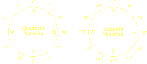
In azimuthal notation, a circle is divided up from 0° to 359° in a clockwise direction. North is 0°, east is 90°, south is 180°, and west is 270°.
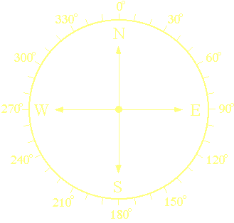
In transfering this to the face of a compass, the numbers increase from 0° to 359° in a counter-clockwise direction (to remain consistent with the reversal of E and W on compasses).
This is called azimuthal notation. If you were facing east, you would say that the azimuth was 90°. If you were facing south, you would say that the azimuth was 180°.
Once again, in azimuth notation, your direction is specified as an angle between 0° and 359° where north is 0°, east in 90°, south is 180°, and west is 270°.
Now let's look at quadrant notation, an alternative to azimuth notation.
Quadrant notation divides the compass face up into quadrants (think of cutting a pie into four equal pieces). There is a northeast, southeast, southwest, and northwest quadrant. Angles are measured east or west of north and east or west of south as shown below.
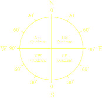
In quadrant notation, you specify a direction as being a certain number of degrees east or west of north or east or west of south (depending upon which quadrant it is). A few examples should clear up any confusion.
Northeast is 45° east of north, southeast is 45° east of south, and southwest is 45° west of south.
Some directions may be specified in two ways. East is 90° east of north or as 90° east of south. Similarly for west (it's 90° west of north or south). North is 0° east of north or 0° west of north. Similarly for south (it's 0° east or west of south).
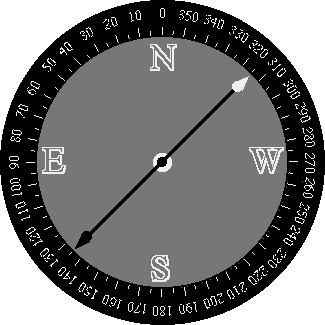
The correct way to write a quadrant notation is N or S (for north or south), followed by an angle, followed by E or W (for east or west). Therefore, N45°W is 45° west of north or northwest.
Below is a compass face set up for quadrant notation and indicating, coincidentally, N45°W.
Converting between azimuth and quadrant notation is pretty straightforward as long as you remember how each are defined. Look at the figure below to compare the two methods.
I personally prefer azimuthal notation because it's the easiest to enter into computer programs which, for example, will plot the data in a stereographic projection (which we'll learn about shortly). Others prefer quadrant notation, and there's nothing wrong with it, but just make sure that whatever method you do use (and that will probably depend on the type of compass you have) is used consistently. In other words, don't keep switching from one method to another when recording data or you'll quickly become confused.
a id="Magnetic"> Magnetic Declination
Many people don't realize that a compass needle does not usually point due north, but at some angle east or west of north. This is because the earth's geographic pole (the axis about which it rotates) is not in the same place as its magnetic pole (the place where the magnetic lines of force emerge from the earth). The direction to the earth's geographic pole is called true north and the direction to the earth's magnetic pole is called magnetic north.
An expedition by the Geological Survey of Canada in 1994 determined that the average position of the north magnetic pole for that year was 78.3° N, 104.0° W (near Ellef Ringnes Island in the Canadian Arctic). They also determined that the magnetic pole was moving approximately 15 km per year.
So, if you're using a compass somewhere on the surface of the earth, you have to account for this difference between magnetic north (where your compass is pointing) and true north (which you need to know). The angle between true north and magnetic north is called the magnetic declination and changes with your location and, at any one location, with time.
How do we determine what the magnetic declination is?
There are some neat computer programs which calculate the magnetic declination at a given latitude and longitude on the earth's surface. What most geologists do, however, is simply consult a recent topographic map for their field area available published by the United States Geologic Survey (and available in many sporting goods stores catering to hikers or hunters) or, if they're working outside of the United States, the USGS also publishes inexpensive maps showing the magnetic declination around the world.
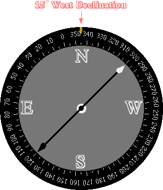
On a typical topographic map, the magnetic declination is indicated as shown below:
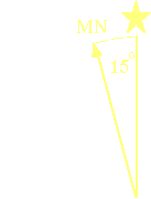
The star indicates true north (toward the top of virtually all maps) and the MN indicates the direction to the north magnetic pole from the center of the map. In this case, the north magnetic pole is 15 deg; west of true north. This means that your compass, unless you correct it, will point 15 deg; west of true north.
There are simple ways to correct for the magnetic declination on most compasses. The Brunton compass, which will be discussed shortly, has an index pin at the north end of the compass ring (the ring around the face of the compass with the azimuths printed on it). When the compass is set for a 0° magnetic declination, the index pin is aligned with zero.
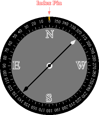
There is a brass setscrew on the side of the compass which moves the compass ring either clockwise or counter-clockwise. The only trick in correcting for magnetic declination is to remember which way to turn the compass ring for east and west declinations.
For a magnetic declination 15 deg; east of true north, you would turn the compass ring such that the index pin was over 15 deg; (i.e. 15 deg; to the east side of north).
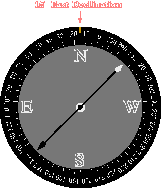
For a 15 deg; west declination, you would turn the compass ring such that the index pin was over 345 deg; (i.e. 15 deg; to the west side of north).
Let's suppose, for example, that you've set your compass for a 15° east declination. You can check to see if the setting is correct by orienting your compass such that the white end of the needle is at 0°. Rotate the compass 15° east and if the white end of the needle is pointing in the same direction of the sighting arm for the compass you're in business.
The Brunton Compass
Geologists use a special type of compass, invented in 1894 by Canadian mining engineer D. W. Brunton, commonly referred to, not surprisingly, as a Brunton compass. The word "Brunton" is actually a company name , but the name is almost always used by geologists to refer to any type of pocket transit compass, even if they're manufactured by other companies. Brunton's are, unfortunately, rather expensive but they're also indispensible tools for the structural geologist.
Let's examine a Brunton compass in a little more detail...

The different features unique to a Brunton compass will be discussed in other tutorials when we learn how to measure the orientations of geologic structures and how to create a geologic map.
Recommended Readings
Want to learn more about compasses and the geomagnetic field? Not everything is on the world-wide web. Here are some good books for learning more about the material covered in this tutorial...
- Backus, G. P., Parker, R. L., & Constable, C. 1996. Foundations of Geomagnetism . Cambridge University Press.
- Compton, R. R. 1985. Geology in the Field . John Wiley.
- Geary, D. 1995. Using a Map and Compass . Stackpole Books.
- Jacobs, J. A. 1987. Geomagnetism . Academic Press.
- Kjellstrom, B. 1994. Be Expert With Map and Compass: The Complete Orienteering Handbook . Collier.
Suggestions, corrections, or comments?
Contact Steven Schimmrich at schimmri@kutztown.edu