Exploration Geophysics

Exploration Geophysics
Why Geophysics?
Seismic
Geo-electrical
Resitvity
Induced Polarisation(IP)
Self-Potential(SP)
Electromagnetic(EM)
Ground Penetrating
Radar(GPR)
Seismo-electric(SE)
Magnetic(Mag)
Gravity
Radiometrics
Why Geophysics?
The earth has it's own physical properties such as different rock densities and layers of strata; rocks that are conductive or radioactive to varying degrees and local variations of the gravitational or magnetic fields.Mineral and hydrocarbon desposts are rare events occupying a tiny portion of the earth's crust.
Consequently the physical properties where they are located are out of the ordinary - referred to by the term "anomalous"
Geophysical exploration involves the search for these anomalies in the earth's crust.
When we measure geophysical properties the results can give us indirect insight into the geology and potential of mineral and hydrocarbon deposits hidden benearth the surface.
An understanding of geophysics such as seismic, gravitational, magnetic, electrical and electromagnetic at the surface of the Earth provides us the means to measure the physical properties of the subsurface, along with the anomalies in those properties.
Uses
Exploration geophysics is most often used to detect or infer the presence and position of economically useful geological deposits, such as ore minerals; fossil fuels and other hydrocarbons; geothermal reservoirs; and groundwater reservoirs.
Detection illuminates the target style of mineralization, via measuring its physical properties directly.
For example
you may
measure the density contrasts between the dense iron ore and the
lighter silicate host rock, or you may measure the electrical
conductivity contrast between conductive sulfide minerals and the
resistive silicate host rock.
The main detection techniques used are:
- Seismic – refraction, reflection,MASW, cross-hole, downhole
- Geo-electrical – resistivity,
- Induced Polarisation (IP),
- Self-Potential (SP)
- Electromagnetic (EM)
- Ground Penetrating Radar (GPR)
- Seismoelectric (SE)
- Magnetic
- Gravity
- Radiometrics
- Borehole Geophysics
Geophysics and Subsurface Mapping
Geophysics may also used to map the subsurface structure of a region, to elucidate the underlying structures, spatial distribution of rock units, and to detect structures such as faults, folds and intrusive rocks.
This is an indirect method for assessing the likelihood of ore deposits or hydrocarbon accumulations.
Geophysics may also be used for:
- monitoring environmental impact
- imaging subsurface archaeological sites
- ground water hydrolgical investigations
- subsurface salinity mapping
- civil engineering site investigations
- interplanetary imaging
Seismic
Seismic surveys measure vibration as it passes through the Earth. This is done using a series of geophones (sensors connected to wires) placed using handheld tools and arranged in an array or specific pattern. This gives information about the properties of the rocks, often down to depths of several kilometres. The vibrations may be induced using truck-mounted vibrating weights or small explosives. Seismic surveys are particularly suited to specific geological forms including flat-lying sedimentary basins. The three methods commonly used for exploration, engineering, and environmental applications are:- refraction
Seismic refraction surveying consists of an in-line geophone array recording the arrival time of subsurface acoustic energy head-waves. The waves are generated from both ends of, and at intermediate locations within the geophone array.
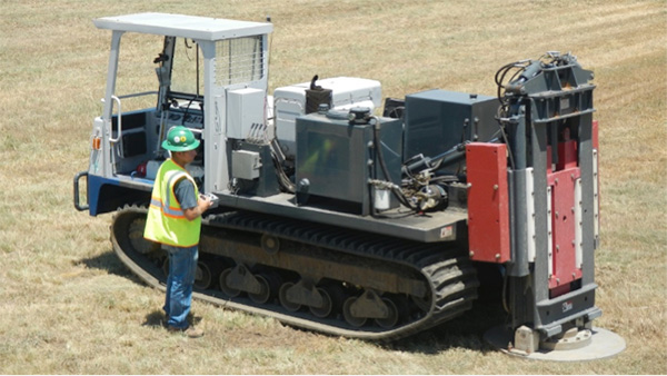
Common energy sources used for shallow surveys include striking a sledgehammer against a steel plate on the ground, or black powder blank explosives (e.g. buffalo gun) triggered in shallow holes (e.g. 30 cm).
For engineering surveys, between 12 and 48 geophones are commonly used to record ground movement at surface.
Depth estimates for refracted energy arrivals can be calculated using the measured head-wave arrival times and known geophone array geometry. Seismic refraction is effective in areas where acoustic energy propagation velocities increase with depth and where there is a significant velocity contrast between upper layer material (e.g. alluvial sediments) overlying more competent lower layer material (e.g. bedrock, ablation till).
The primary limitation of seismic refraction is that it is dependent upon the assumption (for a given survey area) that signal velocities will increase with depth as head-waves propagate through the ground. In instances where low-velocity layers are buried below high-velocity layers (e.g. gravel deposits buried below ablation till sediments) the method will fail to detect the low velocity layer (i.e. hidden layer) and produce erroneous refractor arrival depth estimates.
An additional limitation is that the method requires proper coupling between the geophones and the ground. In areas such as cobble and boulder bars it may not be possible to obtain good ground coupling. Over active channel areas, refraction survey data is prone to significant noise interference from moving water and in most instances data collection is logistically impractical to obtain.
A further requirement of refraction surveys is that the geophone array length must at least 5 to 10 times the distance to the target depth zone of interest. The geophone array must also be in a straight-line to avoid errors in calculated refractor depths. - reflection
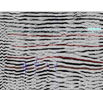
Seismic reflection techniques are the most widely used geophysical technique in hydrocarbon exploration. They are used to map the subsurface distribution of stratigraphy and its structure which can be used to delineate potential hydrocarbon accumulations. Seismic reflection maps contrasts in seismic impedance, which is the product of seismic velocity (the speed at which seismic waves are transmitted by the soil or rock) and density. The “reflection coefficient” – the amount of energy reflected at a boundary – is directly proportional to the difference in seismic impedance. Seismic reflection is much more sensitive to subtle changes and is capable of imaging much finer detail than seismic refraction. However, data acquisition and processing are significantly more complex. - Multichannel Analysis of Surface Waves (MASW)
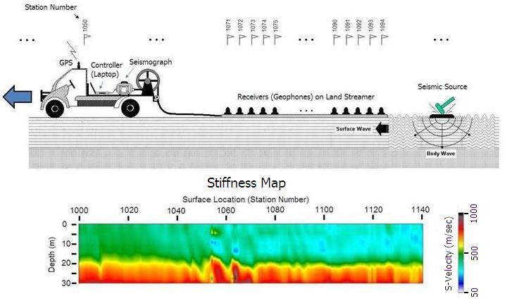
multichannel analysis of surface waves (MASW) method is one of the seismic survey methods evaluating the elastic condition (stiffness) of the ground for geotechnical engineering purposes. MASW first measures seismic surface waves generated from various types of seismic sources—such as sledge hammer—analyzes the propagation velocities of those surface waves, and then finally deduces shear-wave velocity (Vs) variations below the surveyed area that is most responsible for the analyzed propagation velocity pattern of surface waves. Shear-wave velocity (Vs) is one of the elastic constants and closely related to Young’s modulus. Under most circumstances, Vs is a direct indicator of the ground strength (stiffness) and therefore commonly used to derive load-bearing capacity. After a relatively simple procedure, final Vs information is provided in 1-D, 2-D, and 3-D formats.
Geo-electrical - Resistvity
Earth geophysical properties include: density, magnetic susceptibility and permeability, seismic velocity, dielectric permittivity, electrical conductivity/resistivity and chargeability.
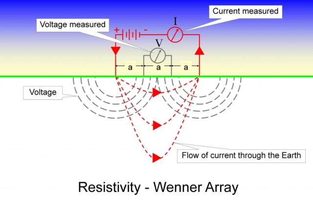
Ohm’s law (V=IR where V is the Voltage I is the Current and R is the resistance), states that the current through a conductor between two points is directly proportional to the voltage across the two points, if you run a current through different materials ou can calculate the electrical resistance by measuring the voltage and current applied.
In practice this means that a resistivity survey will form an electrical circuit through the ground and take voltage and current measurements to calculate the resistivity of the sub-surface rocks.
Controlled Source Electro-Magnetics (mCSEM) can provide pseudo-direct detection of hydrocarbons by detecting resistivity changes over geological traps (signaled by seismic survey).
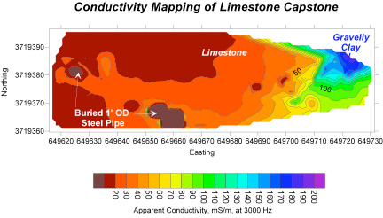
Electrical resistivity tomography (ERT) surveys are relatively new compared with GPR and seismic refraction.ERT is an advanced geophysical technique used to determine the subsurface’s electrical resistivity distribution by making measurements on the ground surface.
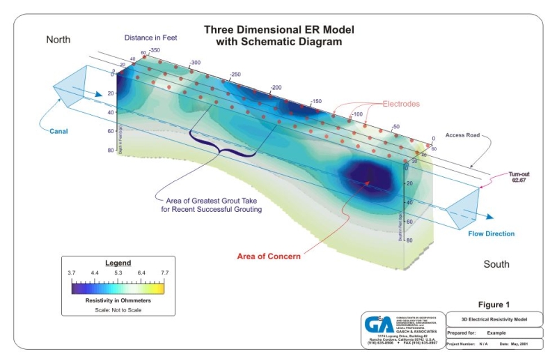
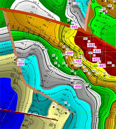
Resistivity, measured in Ωm, is the mathematical inverse of conductivity and represents a bulk physical property that describes how difficult it is to pass an electrical current through the material. ERT involves introducing a DC electrical current into the ground with two electrodes and measuring the voltage drop across the surface of the ground with two other electrodes. Because electrical flow disperses throughout the ground, these surface measurements provide information about the electrical character of materials below the earth’s surface. The primary control on the depth of investigation for a measurement is the distance between the electrodes. ERT profiles are produced by modeling the data from a series of measurements at different depths and locations along a survey line. ERT data are rapidly collected with an automated multi-electrode resistivity meter.
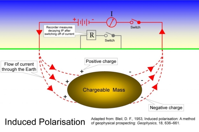
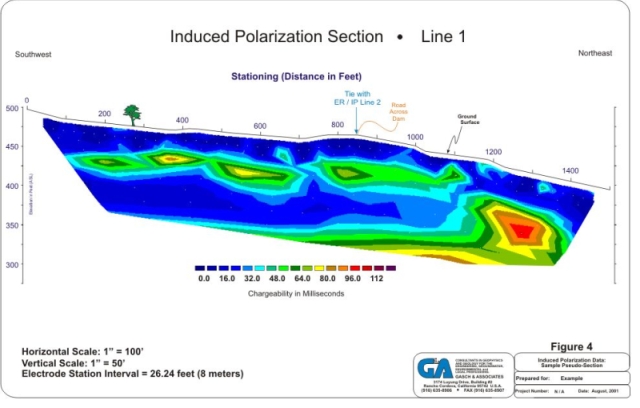
Induced Polarisation (IP)
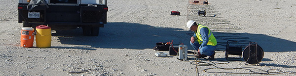
IP surveys induce an electric field in the ground and measure the chargeability and resistivity of the subsurface. The technique can identify changes in the electric currents caused by different rocks and minerals. Readings are taken by a small crew who shift a ground array or pattern of transmission and receiver cables.
In an IP survey, in addition to resistivity measurement, capacitive properties of the subsurface materials are determined as well. As a result, IP surveys provide additional information about the spatial variation in lithology and grain-surface chemistry. IP survey can be made in time-domain and frequency-domain mode. In time domain Induced polarization method, voltage decay is observed as a function of time after the injected current is switched off. In frequency-domain Induced polarization mode, an alternating current is injected into the ground with variable frequencies. Voltage phase-shifts are measured to evaluate impedance spectrum at different injection frequencies, which is commonly referred to as spectral IP
These surveys are most often used in metallic mineral exploration
Surface EM methods are based mostly on Transient EM methods using surface loops with a surface receiver, or a downhole tool lowered into a borehole which transects a body of mineralisation. These methods can map out sulphide bodies within the earth in 3 dimensions, and provide information to geologists to direct further exploratory drilling on known mineralisation. Surface loop surveys are rarely used for regional exploration, however in some cases such surveys can be used with success (e.g.; SQUID surveys for nickel ore bodies).
Self-Potential (SP)
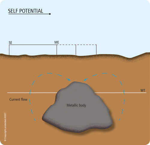
Various potentials are produced in native ground or within the subsurface altered by our actions. Natural potentials occur about dissimilar materials, near varying concentrations of electrolytic solutions, and due to the flow of fluids.
Sulfide ore bodies have been sought by the self potential generated by ore bodies acting as batteries.
Other occurrences produce spontaneous potentials, which may be mapped to determine the information about the subsurface.
Spontaneous potentials can be produced by mineralization differences, electro-chemical action, geothermal activity, and bioelectric generation of vegetation.
Standard SP surveys utilise non-polarising, porous pot electrodes, which have been specially adapted to minimise contact voltages. The electrodes in contact with the ground surface should be the nonpolarizing type, also called porous pots porous pots. Porous pots are metal electrodes suspended in a supersaturated solution of their own salts (such as a copper electrode suspended in copper sulfate) within a porous container. These pots produce very low electrolytic contact potential, such that the background voltage is as small as possible.
Readings are typically taken with one electrode fixed at a base station and a second, mobile 'field' lectrode that is moved around the survey area. Reading stations are spaced at regular intervals along linear profiles, closed loops or grids depending upon the desired application. The self potential method is traditionally used as a mineral exploration tool and for downhole logging in the oil industry. More recently it has been adapted for hydrogeological and water engineering applications, by the use of more sensitive equipment and the careful application of data correction processes.
Electromagnetic (EM)
EM surveys induce an electromagnetic field and measure the three dimensional variations in conductivity within the near-surface soil and rock. Conductive units can be studied to locate metallic minerals, and to understand groundwater and salinity. Ground readings are taken by a small crew who shift a ground array or pattern of transmission and receiver cables.click here for .mp4 video in new window showing how different depths are measured
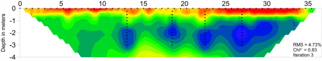
above is the profile based on the video
EM methods generally measure the electrical resistivity of subsurface materials. There are several categories of EM instruments. They are differentiated from one another by either the way they generate or measure electrical potential resulting from the interaction of EM energy surface and subsurface materials.
The main categories include:
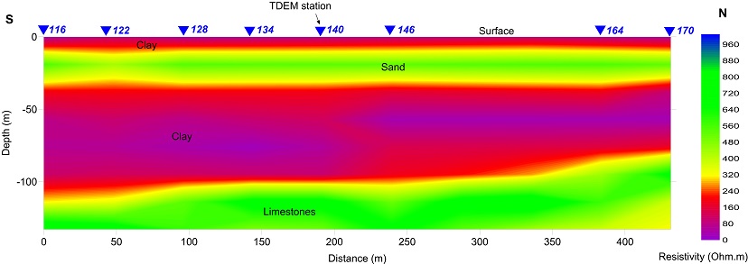
- Frequency Domain,
- Time Domain, and
- Very Low Frequency (FDEM, TDEM, and VLF, respectively)
For Australia there is a transmitter at Exmouth (19.5KHz)that suited N-S striking rocks the one at Woodside Victoria that suited E-W striking rocks was demolished in 2015. , Monte Grande, Argentina(17.3KHz), TGolfo Nuevo, Chubut, Argentina(12.9KHz), Plaine Chabrier, Reunion Island(12.3Khz) Signals from these transmitters act as primary fields that are capable of energizing conductive bodies (such as graphite, metallic minerals and structures) in the ground. Once energized, the current within these bodies emits a secondary field forming the basis for a geophysical exploration.
Electromagnetic (EM) surveys can be used to help detect a wide variety of mineral deposits, especially base metal sulphides via detection of conductivity anomalies which can be generated around sulphide bodies in the subsurface. EM surveys are also used in diamond exploration (where the kimberlite pipes tend to have lower resistance than enclosing rocks), graphite exploration, palaeochannel-hosted uranium deposits (which are associated with shallow aquifers, which often respond to EM surveys in conductive overburden). These are indirect inferential methods of detecting mineralisation, as the commodity being sought is not directly conductive, or not sufficiently conductive to be measurable. Electric-resistance methods such as induced polarization methods can be useful for directly detecting sulfide bodies, coal and resistive rocks such as salt and carbonates.
Ground Penetrating Radar(GPR)
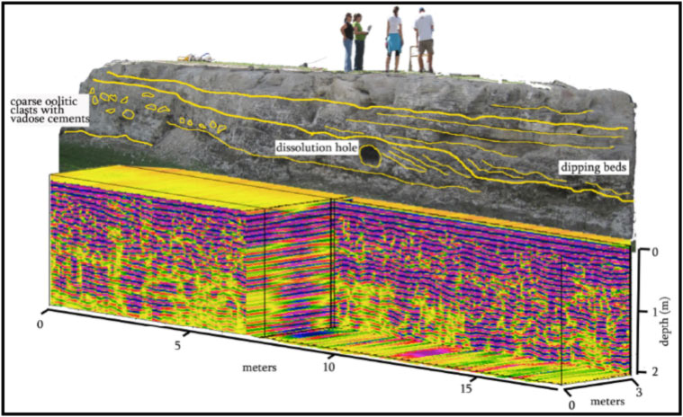
Ground penetrating radar is a general term to describe methods that use radio waves (10 MHz – 1.2 GHz) to probe subsurface objects or geologic features. GPR is a non-invasive electromagnetic (EM) geophysical technique for subsurface exploration and characterization. GPR systems transmit impulse electromagnetic energy (i.e. radio waves) into the ground and detect echoes, or reflected wave front energy, at the ground surface. This process is somewhat similar to p-wave seismic reflection methods and theoretical similarities exist between the kinematic properties of elastic and electromagnetic wave propagation. GPR is capable of profiling sediment stratigraphy and bedrock surface elevations
GPR is a subsurface imaging technique that utilizes high frequency electromagnetic energy (typically in the 50 MHz to 2 GHz range). The EM waves are transmitted into the subsurface and a portion of them are reflected back to a receiver each time an interface between contrasting material types is encountered. The rapid acquisition and processing of GPR data makes it a popular geophysical method for shallow subsurface exploration. However, GPR signals are attenuated rapidly by soils with high clay content thus making it more popular for site with high sand content in the soil.
GPR is useful for a variety of applications, including:
- Soil stratigraphy
- Sub-slab void delineation
- Pavement and sub-base thickness
- Bridge deck assessment
- Buried object location
- Utility locationIce thickness determination
- Bathymetry
- Grave location
- Karst feature mapping
Seismo-electric(SE)
Gravity and magnetics are also used, with considerable frequency, in oil and gas exploration. These can be used to determine the geometry and depth of covered geological structures including uplifts, subsiding basins, faults, folds, igneous intrusions and salt diapirs due to their unique density and magnetic susceptibility signatures compared to the surrounding rocks. Remote sensing techniques, specifically hyperspectral imaging, have been used to detect hydrocarbon microseepages using the spectral signature of geochemically altered soils and vegetation. Specifically at sea, two methods are used: marine seismic reflection and electromagnetic seabed logging (SBL).Marine Magnetotellurics (mMT) or marineMagnetic(Mag)
To a first approximation, Earth’s magnetic field resembles a large dipolar source with a negative pole in the northern hemisphere and a positive pole in the southern hemisphere . The dipole is offset from the center of the earth and also tilted.
The north magnetic pole at the surface of the earth is approximately at Melville Island.
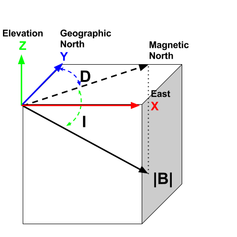
The field at any location on (or above or within) the Earth are generally described in terms described of magnitude (|B||B|), declination (DD) and inclination (II) The magnitude of the vector representing Earth’s magnetic field. DD: Declination is the angle that H makes with respect to geographic north (positive angle clockwise). II: Inclination is the angle between B and the horizontal. It can vary between -90° and +90° (positive angle down).
Most of the magnetic field comes from inside the earth and it can be from the geomagnetic dynamo or from crustal rocks that have become magnetised. In addition there are also magnetic fields that come from outside the earth. The solar wind interacts with Earth’s magnetic field and creates a magnetosphere that is “tear-dropped” shape. This diurnal variation need to be corrected for.
Generally the easiest way to do this is to have two magnetometers - one that is moving and doing the survey and a second that is stationary. The stationary one records the diurnal variation which is then removed from the moving one's data.
This results in a set of magnetic data showing only differences in the earth's magnetic field.
Magnetic surveys measure the variations of the Earth’s magnetic field due to the presence of magnetic minerals. Subtle variations in the abundance of magnetic minerals are used to interpret rock types and can assist in identifying resources. These surveys are typically undertaken by a geophysical technician on foot carrying a magnetometer and a sensor on a pole. They are most often used in metallic mineral exploration.
Magnetometric surveys can be useful in defining magnetic anomalies which represent ore (direct detection), or in some cases gangue minerals associated with ore deposits (indirect or inferential detection). The most direct method of detection of ore via magnetism involves detecting iron ore mineralisation via mapping magnetic anomalies associated with banded iron formations which usually contain magnetite in some proportion. Skarn mineralisation, which often contains magnetite, can also be detected though the ore minerals themselves would be non-magnetic. Similarly, magnetite, hematite and often pyrrhotite are common minerals associated with hydrothermal alteration, and this alteration can be detected to provide an inference that some mineralising hydrothermal event has affected the rocks.
Gravity
A gravimeter measures the gravity field to determine variations in rock density in the Earth’s crust. Ground gravity surveys require a geophysical technician to take gravity measurements at set intervals of distance and record the precise height at each location. Access to the recording sites can be by vehicle or helicopter, depending upon remoteness. These surveys are used in mineral and energy exploration.Contrasts in earth’s gravitational field can often be attributed to local changes in the density of subsurface materials or the presence of engineered structures. Sensitive gravity meters are utilized to measure the gravitational field at designated points within the area of interest
Gravity surveying can be used to detect dense bodies of rocks within host formations of less dense wall rocks. This can be used to directly detect Mississippi Valley Type ore deposits, IOCG ore deposits, iron ore deposits, skarn deposits and salt diapirs which can form oil and gas traps.
Radiometrics

The radiometric, or gamma-ray spectrometric method is a geophysical process used to estimate concentrations of the radioelements potassium, uranium and thorium by measuring the gamma-rays which the radioactive isotopes of these elements emit during radioactive decay.
Airborne gamma-ray spectrometric surveys estimate the concentrations of the radioelements at the Earth's surface by measuring the gamma radiation above the ground from low-flying aircraft or helicopters.
All rocks and soils contain radioactive isotopes, and almost all the gamma-rays detected near the Earth's surface are the result of the natural radioactive decay of potassium, uranium and thorium. The gamma-rays are packets of electromagnetic radiation characterised by their high frequency and energy. They are quite penetrating, and can travel about 35 centimetres through rock and several hundred metres through the air. Each gamma ray has a characteristic energy, and measurement of this energy allows the specific potassium, uranium and thorium radiation to be diagnosed.
The gamma-ray spectrometric method has many applications but is used primarily as a geological mapping tool. Changes in lithology, or soil type, are often accompanied by changes in the concentrations of the radioelements. The method is capable of directly detecting mineral deposits. Potassium alteration, which is often associated with hydrothermal ore deposits, can be detected using the gamma-ray spectrometric method. It is also used for uranium and thorium exploration, heat flow studies and environmental mapping.
Radiometric surveys measure gamma rays which are continuously being emitted from the Earth by natural decomposition of some common radiogenic minerals. Most gamma rays emanate from the top 30 centimetres of rock or soil which can be detected by airborne surveys or on surface rocks using a hand-held spectrometer. These surveys are most often used in metallic and industrial mineral exploration.
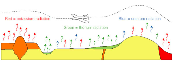
Gamma-ray spectrometers which are designed for the detection and measurement of low-level radiation from both naturally occurring and man-made sources, associated with the radioactive elements; thorium, potassium, and uranium. Gamma Ray Spectrometry provides a direct measurement of the surface of the earth, with no significant penetration, but permits reliable measurement of the radioactive element contacts to the mapped bedrock and surficial geology. Potassium (K), uranium (U) and thorium (Th) are the three most abundant, naturally occurring radioactive elements.
K is a major constituent of most rocks and is the predominant alteration element in most mineral deposits.
Uranium and thorium are present in trace amounts, as mobile and immobile elements, respectively.
As the concentration of these different radioactive elements varies between different rock types, we can use the information provided by a gamma-ray spectrometer to map the rocks.
Where the 'normal' radioelement signature of the rocks is disrupted by a mineralizing system, corresponding radioelement anomalies provide direct exploration guidance.