Streams and Drainage

Streams and Drainage
back to Contents of Entire Course...
Streams
Geometry and Dynamics of Stream
Channels
Changes Downstream
Channel Patterns
Erosion by Streams
Stream Deposits
Drainage Systems
br adapted to HTML from lecture notes of Prof. Stephen A. Nelson Tulane
University Streams
A stream is a body of water that carries rock particles and dissolved ions and flows down slope along a clearly defined path, called a channel. Thus streams may vary in width from a few centimeters to several kilometers. Streams are important for several reasons:
- Streams carry most of the water that goes from the land to the sea, and thus are an important part of the water cycle.
- Streams carry billions of tons of sediment to lower elevations, and thus are one of the main transporting mediums in the production of sedimentary rocks.
- Streams carry dissolved ions, the products of chemical weathering, into the oceans and thus make the sea salty.
- Streams are a major part of the erosional process, working in conjunction with weathering and mass wasting. Much of the surface landscape is controlled by stream erosion, evident to anyone looking out of an airplane window.
- Streams are a major source of water and transportation for the world's human population. Most population centers are located next to streams.
Geometry and Dynamics of Stream Channels
The stream channel is the conduit for water being carried by the stream.
The stream can continually adjust its channel shape and path as the amount
of water passing through the channel changes. The volume of
water passing any point on a stream is called the discharge. Discharge is
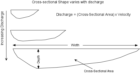
measured in units of volume/time (m3/sec).Cross Sectional Shape - varies with position in the stream, and discharge. The deepest part of channel occurs where the stream velocity is the highest. Both width and depth increase downstream because discharge increases downstream. As discharge increases the cross sectional shape will change, with the stream becoming deeper and wider.
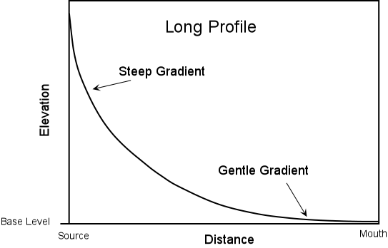
Long Profile - a plot of elevation versus distance. Usually shows a steep gradient near the source of the stream and a gentle gradient as the stream approaches its mouth.
Base Level - base level is defined as the limiting level below which a stream cannot erode its channel. For streams that empty into the oceans, base level is sea level. Local base levels can occur where the stream meets a resistant body of rock, where a natural or artificial dam impedes further channel erosion, or where the stream empties into a lake.
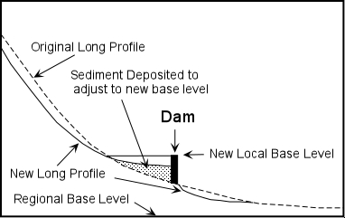
When a natural or artificial dam impedes stream flow, the stream adjusts to the new base level by adjusting its long profile. In the example here, the long profile above and below the dam are adjusted. Erosion takes place downstream from the dam (especially if it is a natural dam and water can flow over the top). Just upstream from the dam the velocity of the stream is lowered so that deposition of sediment occurs causing the gradient to become lower.
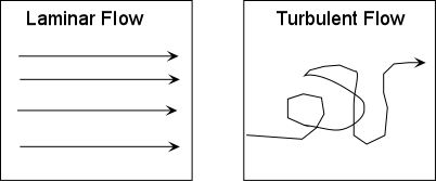
Velocity - A stream's velocity depends on position in the stream channel, irregularities in the stream channel caused by resistant rock, and stream gradient. The average velocity is the time it takes a given particle of water to traverse a given distance. Stream flow can be either laminar, in which all water molecules travel along similar parallel paths, or turbulent, in which individual particles take irregular paths. Turbulent flow can keep sediment in suspension longer than laminar flow and aids in erosion of the stream bottom. Average linear velocity is generally greater in laminar flow than in turbulent flow.
Discharge - The discharge of a stream is the amount of water passing any point in a given time.
- Q = A x V Discharge (m3/sec) = Cross-sectional Area (width x average depth) (m2) x Average Velocity (m/sec)
- As the amount of water in a stream increases, the stream must adjust its velocity and cross sectional area in order to form a balance. Discharge increases as more water is added through rainfall, tributary streams, or from groundwater seeping into the stream. As discharge increases, generally width, depth, and velocity of the stream also increase.
- Load - The rock particles and dissolved ions carried by the stream are the called the stream's load. Stream load is divided into three parts.
- Suspended Load - particles that are carried along with the water in the main part of the streams. The size of these particles depends on their density and the velocity of the stream. Higher velocity currents in the stream can carry larger and denser particles.
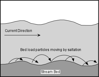
- Bed Load - coarser and denser particles that remain on the bed of the stream most of the time but move by a process of saltation (jumping) as a result of collisions between particles, and turbulent eddies. Note that sediment can move between bed load and suspended load as the velocity of the stream changes.
- Dissolved Load - ions that have been introduced into the water by chemical weathering of rocks. This load is invisible because the ions are dissolved in the water. The dissolved load consists mainly of HCO3- (bicarbonate ions), Ca+2, SO4-2, Cl-, Na+2, Mg+2, and K+. These ions are eventually carried to the oceans and give the oceans their salty character. Streams that have a deep underground source generally have higher dissolved load than those whose source is on the Earth's surface.
Changes Downstream
As one moves along a stream in the downstream direction:
- Discharge increases, as noted above, because water is added to the stream from tributary streams and groundwater.
- As discharge increases, the width, depth, and average velocity of the stream increase.
- The gradient of the stream, however, will decrease.
It may seem to be counter to your observations that velocity increases in the downstream direction, since when one observes a mountain stream near the headwaters where the gradient is high, it appears to have a higher velocity than a stream flowing along a gentle gradient. But, the water in the mountain stream is likely flowing in a turbulent manner, due to the large boulders and cobbles which make up the streambed. If the flow is turbulent, then it takes longer for the water to travel the same linear distance, and thus the average velocity is lower. Also as one moves in the downstream direction,
- The size of particles that make up the bed load of the stream tends to decrease. Even though the velocity of the stream increases downstream, the bed load particle size decreases mainly because the larger particles are left in the bed load at higher elevations and abrasion of particles tends to reduce their size.
- The composition of the particles in the bed load tends to change along the stream as different bedrock is eroded and added to the stream's load.
Floods
Floods occur when the discharge of the stream becomes too high to be accommodated in the normal stream channel. When the discharge becomes too high, the stream widens its channel by overtopping its banks and flooding the low-lying areas surrounding the stream. The areas that become flooded are called floodplains.
Channel Patterns
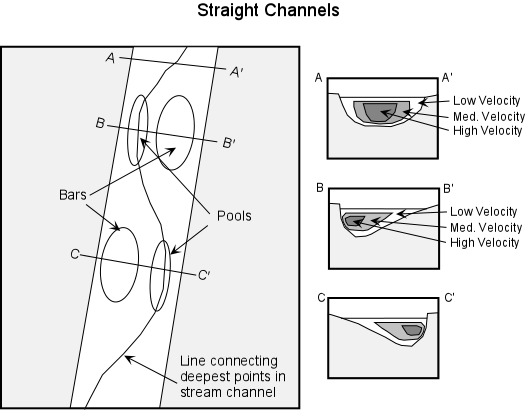
- Straight Channels - Straight stream channels are rare. Where they do occur, the channel is usually controlled by a linear zone of weakness in the underlying rock, like a fault or joint system. Even in straight channel segments water flows in a sinuous fashion, with the deepest part of the channel changing from near one bank to near the other. Velocity is highest in the zone overlying the deepest part of the stream. In these areas, sediment is transported readily resulting in pools. Where the velocity of the stream is low, sediment is deposited to form bars. The bank closest to the zone of highest velocity is usually eroded and results in a cutbank.
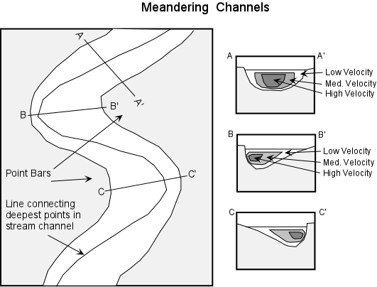
- Meandering Channels - Because of the velocity structure of a stream, and especially in streams flowing over low gradients with easily eroded banks, straight channels will eventually erode into meandering channels. Erosion will take place on the outer parts of the meander bends where the velocity of the stream is highest. Sediment deposition will occur along the inner meander bends where the velocity is low. Such deposition of sediment results in exposed bars, called point bars. Because meandering streams are continually eroding on the outer meander bends and depositing sediment along the inner meander bends, meandering stream channels tend to migrate back and forth across their flood plain.
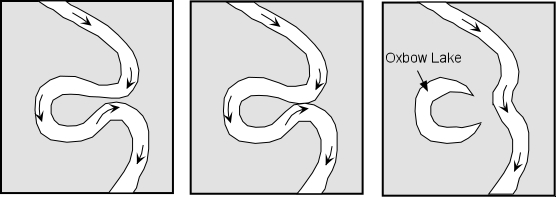
- If erosion on the outside meander bends continues to take place, eventually a meander bend can become cut off from the rest of the stream. When this occurs, the cutoff meander bend, because it is still a depression, will collect water and form a type of lake called an oxbow lake.
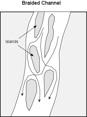
- Braided Channels - In streams having highly variable discharge and easily eroded banks, sediment gets deposited to form bars and islands that are exposed during periods of low discharge. In such a stream the water flows in a braided pattern around the islands and bars, dividing and reuniting as it flows downstream. Such a channel is termed a braided channel. During periods of high discharge, the entire stream channel may contain water and the islands are covered to become submerged bars. During such high discharge, some of the islands could erode, but the sediment would be re-deposited as the discharge decreases, forming new islands or submerged bars. Islands may become resistant to erosion if they become inhabited by vegetation
Erosion by Streams
Streams erode because they have the ability to pick up rock fragments and transport them to a new location. The size of the fragments that can be transported depends on the velocity of the stream and whether the flow is laminar or turbulent. Turbulent flow can keep fragments in suspension longer than laminar flow. Streams can also eroded by undercutting their banks resulting in mass-wasting processes like slumps or slides. When the undercut material falls into the stream, the fragments can be transported away by the stream. Streams can cut deeper into their channels if the region is uplifted or if there is a local change in base level. As they cut deeper into their channels the stream removes the material that once made up the channel bottom and sides.
Stream Deposits
Sudden changes in velocity can result in deposition by streams. Within a stream we have seen that the velocity varies with position, and, if sediment gets moved to the lower velocity part of the stream the sediment will come out of suspension and be deposited. Other sudden changes in velocity that affect the whole stream can also occur. For example if the discharge is suddenly increased, as it might be during a flood, the stream will overtop its banks and flow onto the floodplain where the velocity will then suddenly decrease. This results in deposition of such features as levees and floodplains. If the gradient of the stream suddenly changes by emptying into a flat-floored basin, an ocean basin, or a lake, the velocity of the stream will suddenly decrease resulting in deposition of sediment that can no longer be transported. This can result in deposition of such features as alluvial fans and deltas.
- Floodplains and Levees - As a stream overtops its banks during a flood, the velocity of the flood will first be high, but will suddenly decrease as the water flows out over the gentle gradient of the floodplain. Because of the sudden decrease in velocity, the coarser grained suspended sediment will be deposited along the riverbank, eventually building up a natural levee. Natural levees provide some protection from flooding because with each flood the levee is built higher and therefore discharge must be higher for the next flood to occur.
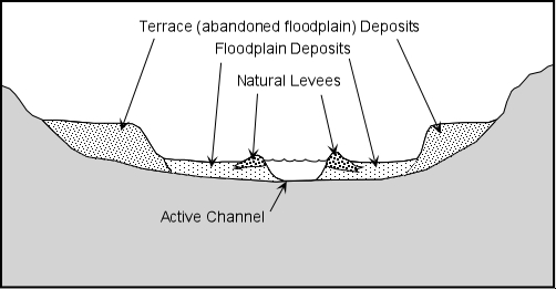
- Terraces - Terraces are exposed former floodplain deposits that result when the stream begins down cutting into its flood plain (this is usually caused by regional uplift or by lowering the regional base level, such as a drop in sea level).
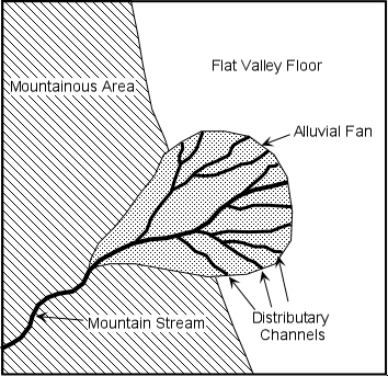
- Alluvial Fans - When a steep mountain stream enters a flat valley, there is a sudden decrease in gradient and velocity. Sediment transported in the stream will suddenly become deposited along the valley walls in an alluvial fan. As the velocity of the mountain stream slows it becomes choked with sediment and breaks up into numerous distributary channels.
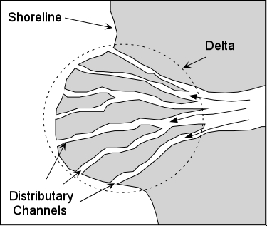
- Deltas - When a stream enters a standing body of water such as a lake or ocean, again there is a sudden decrease in velocity and the stream deposits its sediment in a deposit called a delta. Deltas build outward from the coastline, but will only survive if the ocean currents are not strong enough to remove the sediment. As the velocity of a stream decreases on entering the delta, the stream becomes choked with sediment and conditions become favorable to those of a braided stream channel, but instead of braiding, the stream breaks into many smaller streams called distributary streams.
Drainage Systems
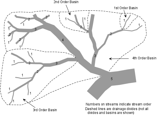
- Drainage Basins and Divides - Drainage systems develop in such a way as to efficiently move water off the land. Each stream in a drainage system drains a certain area, called a drainage basin. In a single drainage basin, all water falling in the basin drains into the same stream. Drainage basins can range in size from a few km2, for small streams, to extremely large areas, such as the Mississippi River drainage basin which covers about 40% of the contiguous United States . A divide separates each drainage basin from other drainage basins.
- Stream Order - The smallest streams in a drainage network have no tributary streams. These are called first order streams. Two first order streams unite to form a second order stream. Second order streams only have first-order streams as tributaries. Third order streams only have second and first order streams as tributaries, etc. As the order of the stream increases, the discharge increases, the gradient decreases, the velocity increases, and the channel dimensions (width and depth) increase to accommodate the increased discharge.
- Drainage Patterns - Drainages tend to develop along zones where rock type and structure are most easily eroded. Thus various types of drainage patterns develop in a region and these drainage patterns reflect the structure of the rock.