Flood Model Development

Flood Model Development
How to Make a Flood Model
Comparing Model
and Actual Rainfall at Innisfail
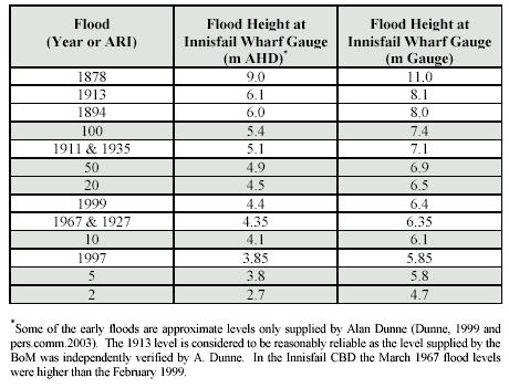
Design Floods
-Hypothetical Floods Used for Planning
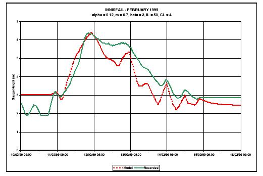
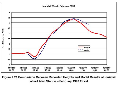
Calibrating the
Flood Model example 1999 flood
Design Hydrology
The two main methods of determining the magnitude of the flow for a
design event
Method 1. Flood frequency analysis
(FFA)
Method 2 Design
rainfalls with the URBS Model
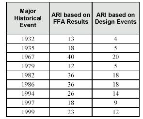
General Agreement between
the two Models
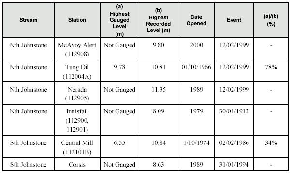
Historical Evidence of Flood
Levels
Ultimately Which River Levels Constiute a Flood is a Human Decision
based on Both Models and Historical Evidence
Adopted Peak Flows - A Human
Decision
How to Make a Flood Model
The flood model comprises a hydrological model and a hydraulic model. The hydrologic model determines the runoff that occurs following a particular rainfall event. The primary output from the hydrologic model is hydrographs at varying locations along the waterways to describe the quantity, rate and timing of stream flow that results from rainfall events. These hydrographs then become a key input into the hydraulic model. The hydraulic model simulates the movement of flood waters through waterway reaches, storage elements, and hydraulic structures. The hydraulic model calculates flood levels and flow patterns and also models the complex effects of backwater, overtopping of embankments, waterway confluences, bridge constrictions and other hydraulic structure behaviour.The Bureau of Meteorology (BoM) has established and calibrated an URBS hydrologic model of the Johnstone River catchment. This model was reviewed and adopted for the study. Some minor modifications to the model sub-catchments were done by WBM to match the locations of the hydraulic model boundaries.
The complicated nature of the floodplain flow patterns and importance of obtaining community confidence in the process required that state-of-the-art modelling techniques be adopted. For these reasons, TUFLOW, a fully 2D dynamic hydraulic modelling system was adopted. In total, the hydraulic model covers approximately 125 km2 of the rivers and floodplain.
Comparing Model and Actual Rainfall at Innisfail
Design Floods -Hypothetical Floods Used for Planning
Design floods are hypothetical floods used for planning and floodplain management investigations. A design flood is defined by its probability of occurrence. It represents a flood which has a particular probability of occurring in any one year. For example, the 1% Annual Exceedence Probability (AEP)or 1 in 100 Average Recurrence Interval (ARI) flood is a best estimate of a flood which has 1 chance in 100 of occurring in any one year. It should be noted that planning for the 1 in 100 year ARI flood does not guarantee protection for the next 100 years.
Design flood levels, flows and velocities were determined for 100, 50, 20, 10, 5 and 2 year ARI floods.
The design floods were used to make an assessment of the financial losses to residential and commercial properties. These financial losses were then used as a basis to do an economic assessment of potential floodplain management measures. Historical damage to public infrastructure was documented where information was available.
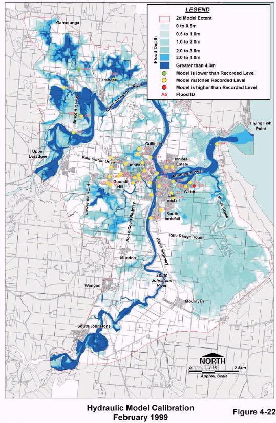
Calibrating the Flood Model example 1999 flood
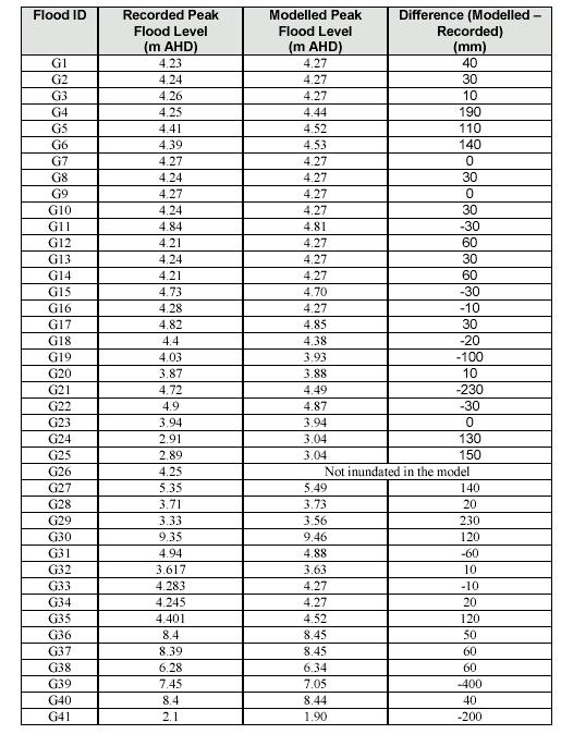
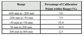
Overall, good agreement between recorded and hydraulic model flood levels was obtained for the
calibration events, especially in the most recent February 1999 flood indicating that the model is reliably predicting the flooding behaviour of the current floodplain. It is recommended that results from the southern part of the hydraulic model be used with caution, as this part of the model was not calibrated.
Design Hydrology
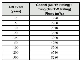
Design floods are hypothetical floods used for planning and floodplain management investigations. A design flood is defined by its probability of occurrence. It represents a flood that has a particular probability of occurring in any one year. For example, the 1% AEP or 1 in 100 ARI flood is a best estimate of a flood which has 1 chance in 100 of occurring in any one year. It is important to acknowledge that the 100 year ARI event may occur more than once in a 100 year period as the definition of the event is that it occurs once, on average, in 100 years. Therefore, planning for the 1 in 100 year ARI flood does not guarantee protection for the next 100 years. Similarly, the 100 year ARI event may not occur at all within a 100 year period for the same reason. The 2 year, 5 year, 10 year, 20 year, 50 year and 100 year ARI were analysed.
The two main methods of determining the magnitude of the flow
There are two main methods of determining the magnitude of the flow for a design event. These are listed below and explained in the following sections:Method 1.Flood frequency analysis (FFA)
Flood frequency analysis (FFA) enables the magnitude of floods of selected ARI (Average Recurrence Interval) to be estimated by statistical analysis of recorded historical floods.
North Johnstone River
South Johnstone River
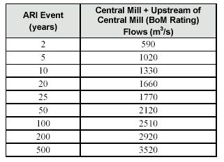
Method 2. Design rainfalls with the URBS Model
Design flood events are produced using design rainfall events. To determine the intensity and distribution of rainfall that will produce a specified ARI design event, charts developed by the Bureau of Meteorology (BoM) are consulted. These charts are contained in a book called “Australian Rainfall and Runoff”(IEAust, 2001).
General Agreement between the two Models
Plus Historical Acedotal Evidence
It is really important that whatever model you use, you check it against some real-life flood data. No model is perfect, at best a model is a reasonal approximation of reality. If it does not line up with reak events then the model is of little value.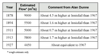
Adopted Peak Flows - Human Decision
Based on the models and the real data we must now make an informed human decision as to what flow levels constitute a 2,5,10,20,50,100 year flood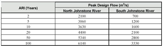
Comparison between historical and defined flood model