Case Study Johnstone River Flooding

Case Study Johnstone River Flooding
Flood Warning System for the JOHNSTONE RIVER - based on information provided to the public by the BOM
Flood Risk
Previous Flooding
Flood Forecasting
Johnstone River ALERT System
Flood Warnings and Bulletins
Telephone Weather Products
Interpreting
Flood Warnings and River Heights
Assessment of the Flood
Potential
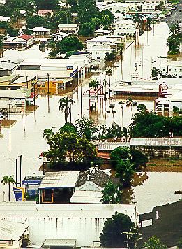
Johnstone River in flood at Innisfail February 1999 (Cyclone Rona)
Photo: Brian Cassey
Flood Risk
The North and South Johnstone Rivers rise in the tablelands of the north tropical coast and flow through steep narrow gorges to their junction on the coastal plain at Innisfail. The headwaters of the catchments are located in high rainfall areas and the rivers are capable of producing severe flooding, especially in the Innisfail area. The North and South Johnstone Rivers have a combined catchment area of about 1,600 square kilometres at Innisfail.There is a strong rainfall gradient across the catchment with the heaviest rain generally falling along the eastern side of the catchment around Topaz, Crawfords Lookout and Innisfail. In the western area of the catchment, rainfall totals tend to be significantly less. Heavy localised rainfall along the coastal strip to Crawfords Lookout can cause rapid river rises in the lower Johnstone Rivers around Innisfail and Mourilyan, although larger floods tend to be associated with catchment wide heavy rainfalls.
The Johnstone River delta area can be subject to severe flooding with low lying areas being susceptible. Large areas of agricultural areas can be inundated and residential areas affected. Tides can have a significant impact on the smaller floods but little effect in larger floods.
Previous Flooding
Severe flooding of the Johnstone River is often associated with tropical cyclones. The two highest floods at Innisfail in recent years occurred in February 1986 and March 1967. The flood records for Innisfail indicate that the highest recorded flood occurred in 1913 and that it was about 1.5 metres higher than the 1986 flood. Historical evidence indicates that the floods in 1893 and 1894 were even higher.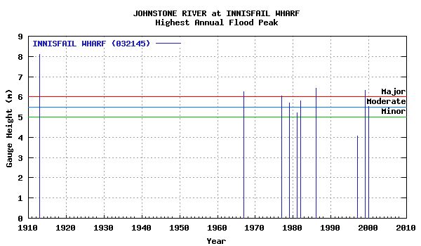
Flood Forecasting
The Johnstone Shire Council, in conjunction with the Bureau of Meteorology operates a flood warning system for the Johnstone River catchment. The ALERT network consists of automatic rainfall and river height stations which regularly forward data via radio telemetry to a base station located at the Council offices in Innisfail and the Bureau's Flood Warning Centre in Brisbane. The system provides early warning of heavy rainfall and river rises in the catchment and enables more accurate and timely flood warning and forecasts. The balance of the network consists of volunteer rainfall and river height observers, who forward observations by telephone when the initial flood height has been exceeded at their station. The Department of Natural Resources also operate a number of automatic telephone telemetry stations throughout the catchment.The Bureau's Flood Warning Centre issues Flood Warnings and River Height Bulletins for the Johnstone River catchment during flood events. Quantitative flood forecasts are issued when moderate flood levels are likely to be exceeded at Innisfail, with an objective to provide between 3 and 9 hours warning of flood levels and forecasts updated every 3 hours during the flood event.
Johnstone River ALERT System
The Johnstone River ALERT flood warning system was completed in 1989 as a co-operative project between the Bureau of Meteorology and the Johnstone Shire Council. The system comprises a network of rainfall and river height field stations located on the Tablelands as well as the coastal plain which report via VHF radio to a base station computer located in the Council office in Innisfail.The field stations send reports for every 1 millimetre of rainfall and every 50 millimetre change in river height.In consultation with the Johnstone Shire Council, the Bureau issues Flood Warnings for the Johnstone River.
The base station computer located in the Johnstone Shire Council office collects the data and has software that displays it in graphical and tabular form. The data is also received by the Bureau's Flood Warning Centre where it is used in hydrologic models to produce river height predictions.
Flood Warnings and Bulletins
The Bureau of Meteorology issues Flood Warnings and River Height Bulletins for the Johnstone River catchment regularly during floods. They are sent to radio stations for broadcast, and to local Councils, emergency services and a large number of other agencies involved in managing flood response activities. Flood Warnings and River Height Bulletins are available via :Radio
Radio stations, particularly the local ABC, and local commercial stations, broadcast Flood Warnings and River Height Bulletins soon after issue.
Local response organisations
These include the Councils, Police, and State Emergency Services in the local area.
Internet/World Wide Web
Flood Warnings, River Height Bulletins and other weather related data is available on the Bureau's Web page at http://www.bom.gov.au/ . The Queensland Flood Warning Centre website is http://www.bom.gov.au/hydro/flood/qld
Telephone Weather
Flood Warnings are available through a recorded voice retrieval system, along with a wide range of other weather related and climate information.
| Main Directory |
Tel |
1900 955 360 |
Flood Warnings |
Tel |
1300 659 219 |
Telephone Weather Services Call Charges:
1900 numbers: 77c per minute incl. GST; 1300 numbers: Low call cost - around 27.5c incl. GST. (More from international, satellite, mobile or public phones)
Weather by Fax
Flood Warnings and River Height Bulletins are also available through a facsimile information retrieval system, along with a wide range of other weather related and climate information.
| Main Directory (Free call) | 1800 630 100 | |
|---|---|---|
| Flood Warnings |
Fax No. |
1902 935 065 |
| River Height Bulletins |
Fax No. |
1902 935 057 |
Weather by Fax Call Charges: 1902 numbers: 66c per minute, incl. GST; 1800 numbers: Free (More from international, satellite, mobile or public phones)
Interpreting Flood Warnings and River Height Bulletins
Flood Warnings and River Height Bulletins contain observed river heights for a selection of the river height monitoring locations. The time at which the river reading has been taken is given together with its tendency (e.g. rising, falling, steady or at its peak). The Flood Warnings may also contain predictions in the form of minor, moderate or major flooding for a period in the future. River Height Bulletins also give the height above or below the road bridge or causeway for each river station located near a road crossing.
One of the simplest ways of understanding what the actual or predicted river height means is to compare the height given in the Warning or Bulletin with the height of previous floods at that location.
The table below summarises the flood history of the Johnstone River catchment - it contains the flood gauge heights of the highest know floods recorded at selected river height locations, together with heights of recent floods.
| Highest Recorded Flood (in metres) | Mar 1967 | Apr 1982 | Feb 1986 | Feb 1999 | |||
|---|---|---|---|---|---|---|---|
| Nerada |
Feb 1999 |
11.15 |
|
|
|
10.30 |
11.15 |
| Tung Oil |
Feb 1999 |
10.81 |
10.33 |
10.19 |
10.17 |
9.34 |
10.81 |
| Corsis |
Mar 1997 |
6.68 |
|
|
|
6.68 |
6.68 |
| Central Mill |
Mar 1967 |
11.13* |
11.13* |
8.10 |
10.84 |
9.85 |
9.70 |
| Innisfail |
- 1913 |
8.09* |
6.25* |
5.81* |
6.42* |
5.85 |
6.37 |
[*] These heights are taken at old gauge sites and may not relate to flood levels from existing gauges sites.
Assessment of Flood Potential
Major flooding requires a large scale rainfall situation over the Johnstone River catchment. The following can be used as a rough guide to the likelihood of flooding in the catchment:
Average catchment rainfalls of in excess of 200mm in 24 hours may cause stream rises with moderate to major flooding and traffic disabilities to develop, particularly in the lower reaches downstream of Nerada on the North Johnstone River and Corsis on the South Johnstone River extending to the coastal plain around the Innisfail township and the mouth of the Johnstone River.
Average catchment rainfalls of in excess of 300mm in 24 hours may cause significant stream rises with major flooding and traffic disabilities to develop, particularly in the lower reaches downstream of Nerada on the North Johnstone River and Corsis on the South Johnstone River extending to the coastal plain around the Innisfail township and the mouth of the Johnstone River.
Each river height station has a pre-determined flood classification which details heights on gauges at which minor, moderate and major flooding commences. Other flood heights may also be defined which indicate at what height the local road crossing or town becomes affected by floodwaters.
The table below shows the flood classifications for selected river height stations in the Johnstone River catchment.
River Height Station |
First Report Height | Crossing Height | Minor Flood Level | Crops & Grazing | Moderate Flood Level | Towns and Houses | Major Flood Level |
|---|---|---|---|---|---|---|---|
| Nerada | 6.0 | 7.0 | 8.0 | ||||
| Tung Oil | 7.0 | 8.0 | 8.5 | ||||
| McAvoy Br | 7.1 (B) | 5.0 | 6.0 | 7.1 | |||
| Corsis | 5.0 | 5.5 | 6.0 | ||||
| Central Mill | 3.9 (B) | 7.5 | 8.0 | 8.5 | |||
| Innisfail | 3.5 | 5.0 | 5.5 | 6.0 | 6.0 |